Wednesday, January 6, 2010

Baja California: Lighthawk Mission #2 - La Paz to Cabo Pulmo


This morning we take off in La Paz and head south for the Cape region. The mission today is to photograph the rampant development along the tourist corridor from Cabo San Lucas to San Jose del Cabo, then continue on to the East Cape where Cabo Pulmo Park is located and the next phase of mega-development has already begun.

We see the craziness as we approach Land’s End, at the extreme southern tip of the Baja peninsula. When most people think of Baja they picture CaboSan Lucas, with it's non-stop spring break atmosphere, high-end golf courses, and luxury hotels. There are two large cruise ships in harbor as we circle the bay. Like little gnats dancing on the water, jet skies and speed boats dart in every direction. The sleepy little fishing town that North Americans first flocked to Cabo for has disappeared. Few people realize that the bay of CaboSan Lucas is actually a protected area for fauna and flora.


Following the coastline to San Jose delCabo we pass hotel after hotel and more than a dozen golf courses strung out like carpets in the sand. One patch of coastline near Playa Santa Maria catches my eye because it has been scrapped clean of all vegetation for nearly a mile along the coast. The project looks dormant, maybe waiting for better economic times. No doubt the rains of summer and hurricanes that come in summer and fall will cause severe erosion.


Passing over all the major hotels and resorts—Hilton, Westin, Palmia—we come to San Jose del Cabo with its large estuary guarded from the open ocean by a barrier beach of pure white sand. We can see Puerto Los Cabos (puertoloscabos.com) the huge new marina and resort complex that was dug into the coastline. This project was strongly opposed due to the impacton fishing town of La Payita and the freshwater estuary at the mouth of the San Jose River.


It’s a huge relief as we leave Los Cabo behind and follow the coast north to Cabo Pulmo National Park, one of the jewels of the Baja California. We follow the coast road that is slated to be paved, no doubt opening up this more remote area to development. Ahead of us now is the small town of Cabo Pulmo. We circle a couple of times to photograph the only true coral reef in the Sea of Cortez. A polarizing filter brings out the reef structure and turquoise waters.


Not far from Cabo Pulmo is the lighthouse at Punta Arenas (Sandy Point), and the site of Cabo Cortez (cabocortes.com) the largest of all the proposed developments in the Cape region. It’s hard to imagine the scale of what is planned here along this pristine beach so close to Cabo Pulmo National Park. The development includes a marina (yes, another one dug into the coast), golf courses, homesites, hotels and condos, a new airport for private jets, plus a commercial center and a small city to house all the workers that will be needed to build then staff the project. Future projections include upward of 20,000 people spread across the desert and sandy coast below. A depressing thought for those of us to come to Baja for it’s wild coast and marine life.


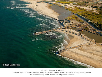
In case it was hard to envision the plans for Cabo Cortez, the flight brings us to La Ribera where construction has already begun on Cabo Riviera (CaboRiviera.com). Below us is heavy equipment and dredges working in the estuary at the mouth of the San Dioniaio wash, from where the town of La Ribera gets its freshwater. This is one of the windiest sections of the Baja coast and erosion is already taking its toll. Alarmingly, the public beach where local fisherman launch their pangas is disappearing.


The master plan here is to dig a man-made bay for the marina, waterfront homes, resort hotel, and golf course. Ironically, the town La Ribera was relocated from this site in the 1970's due to repeated storm and flood events. Makes us wonder if this development is not doomed to the same fate.


We touch down in La Paz just before dark. On approach we detour to photograph Espiritu Santo Island, one of the conservation success stories. Once threatened by development, local and international conservation groups stepped in to buy the island which is now protected as a National Park.

Painted golden in the warm rays of the setting sun, the story of Espiritu Island restores a small glimmer of hope among all the current and proposed developments.


Tuesday, January 5, 2010

Baja California: Lighthawk Mission #1 - Phoenix to La Paz

January 5, 2010

What impresses me most from the air is how vast and wild Baja California still is. Arriving in Loreto following our flight across the Gulf of California from Phoenix, my Lighhawk pilot, Chuck Heywood, takes off the doors of our Cessna 206. Lighthawk is an active group of volunteer pilots who fly missions for conservation, and we are here in Baja to fly and photograph the coast from Loreto to La Paz. Tomorrow we will continue on from La Paz to Cabo San Lucas. With the plane gassed up and ready to go, he fits me in the harness with my camera mounted on a gyro stabilizer for extra stability. It's wheels up two hours before sundown. Perfect timing.

Our first target is the development at Loreto Bay. Touted as "green" and "sustainable," the high-density construction looks like a slice of Disneyland from the air. At first glance the colorful buildings and golf course look inviting. But the impact of development of this scale is huge: construction in a wetland ecosystem, lack of adequate infrastructure (limited freshwater resources and inadequate sewage treatment facilities), and the influx of workers from the poorest parts of mainland Mexico. Offshore is Loreto Bay National Park, home to a third of the whale species on earth. The project is
now bankrupt. The legacy of boom and bust continues.


Heading south along the coast from Loreto our next target is Ensenada
Blanca, a remote bay that was once the location of
Danzante Eco-Resort. This bay is the poster child of the change that is happening along the Baja peninsula. Danzante was a small,
environmentally friendly resort with a limited footprint on the land.
It employed local people, with the beach was accessible to all, including the fisherman from the villages of
Ligui and Ensenada Blanca who launched their pangas here for generations to fish the rich waters offshore. Threatened by lawsuits and strong-arm tactics from the developers (VillaGroupResorts), local land owners finally sold out. Construction started soon thereafter. Another pristine Baja bay never to be the same.


Continuing south the jagged peaks of the Sierra de la Giganta begin to
cast a shadow along the coast. We're on the lookout for another planned development, this one slated for a saltwater lagoon near the fishing community of
Agua Verde. We see the lagoon ahead. With the site plan for the development website in hand (PuertodeSanCosme),
it doesn't take any imagination to envision what is planned--a
breakwater, marina, and waterfront homes--along what is now a remote
section of the coast. Construction has not yet begun, so maybe there's
hope.


As the sun nears the horizon, La Paz comes into view. Our flightpath
for landing takes us directly over the El
Mogote peninsula where
another tragic development is occurring, Paradise by the Sea (
ParadiseoftheSea). Once public land, El Mogote is another example of a project that should have never received permits from the Mexican government. The peninsula is a barrier beach, dune, and wetland ecosystem that protects the inner La Paz harbor for storm surges. Close to shore is a known whale shark
area. What should have been preserved for future generations to enjoy is now being carved up for shot-term profit. While the condos are reportedly sinking into the sand, their foundations cracking,
lawsuits are pending to stop the continued destruction.


On the ground in La Paz exhausted. Baja California from the air is
breathtaking. If the
Baja peninsula was part of the US, much of it
would look like San Diego today. South of the border everything
changes. A lack of freshwater and infrastructure has protected
Baja
from the fate of other desirable coastlines, like southern California
and Florida, for example. Although it's still the good old days in some parts of
Baja, things are changing fast. Big-money developers have Baja in the cross-hairs. "Baja is for the taking," a corporate pilot tells me, before firing up his Beechcraft turboprop at the La
Paz Airport.

Tomorrow we fly from La
Paz to the Cape region, where we will witness more of the uncontrolled growth that puts Baja's coast and marine protected areas at risk.